ABC News(NEW YORK) — A weak disturbance is bringing areas of rain to parts of the mid-Atlantic and Northeast on Sunday morning. The disturbance is tapping into moisture in the southern Atlantic and is enhancing the rainfall along the immediate coast line of the Carolinas.
But the system will slide off to the north and east, pushing the heavier rain into the open ocean. Some scattered showers will remain in the mid-Atlantic and Northeast through early Monday as the system pulls away.
The system will definitely spread some cloud cover to much of the East Coast, and help pull down some cooler air from Canada. With high temperatures in the low to mid 60s on Sunday in the Northeast, it will feel nearly 25 degrees colder than Thursday and Friday.
Morning temperatures on Monday will slip into the 40s in some spots of the interior Northeast and Great Lakes. This is a pretty drastic change from the 80- and 90-degree temperatures during the afternoon late last week.
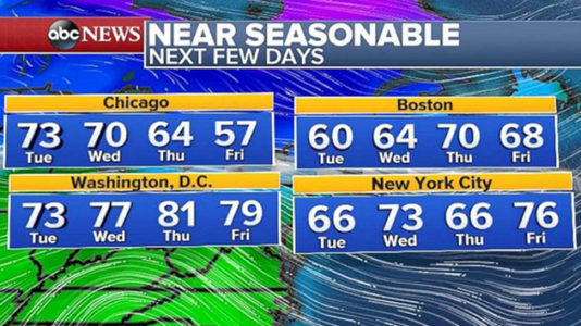
Some building warmth in the West will try to expand to the Northeast this week. However, a couple of weak systems moving across the northern U.S. will try to bring cooler air south as well. As a result, parts of the Midwest and much of the Northeast will see a semi-seasonable week ahead with only slight deviations in temperature.
Daytime temperatures for much of the region should be in the mid to upper 60s in early May. The best chance for warmth looks to come toward the end of the week.
Excessive heat in Southwest
Excessive heat warnings have been posted Sunday for parts of Arizona and California as temperatures will rise into the triple digits. A couple of records could be broken in this region on Sunday.
The warmth is expanding across the West, with temperatures nearly 10 degrees above average from Phoenix to Denver and from Salt Lake City to Billings, Montana, on Sunday.
Some of the warmth will expand into the Plains on Monday with temperatures into the low 90s in Dallas and upper 80s in Oklahoma City. The warmth brings some upper 70s from Nebraska to Minnesota as well. All of the temperatures are nearly 10 degrees above seasonable averages.
Also of note, with a strong high pressure in the central U.S., dry northerly winds effectively keep moisture from the Gulf limited. As a result, there are notable concerns for severe weather in the next several days.
Long-term outlook
Mild weather looks like it will win out in the longer-term forecast for the entire country. As we head toward mid-May, it is increasingly likely that another round of warmer-than-average temperatures will make their way to the Northeast. Meanwhile, the warmth looks like it will be stubborn in the Southwest.
In fact, the next several weeks look likely to have mild- and above-average temperatures across the entire U.S., with no big shots of cool air in sight. This is definitely a sign of the jet stream lifting northward and cold air retreating north of the continental U.S. as the calendar heads to summer.
Copyright © 2018, ABC Radio. All rights reserved.